$4,500.00
Marine Satellite Speed Log SDME GSL9000
nSatellite speed logs have become increasingly important in the maritime industry over the past few years in monitoring vessel speed and distance travelled. They are also known as Speed and Distance Measuring Equipment, or SDME.
nSo what are satellite speed logs and how do they work? Essentially, these devices use satellite signals to determine a vessel’s speed and distance travelled through water. They work by emitting a signal from the vessel which is then picked up and reflected back by satellites. The speed log then measures the time it takes for the signal to travel from the vessel to the satellite and back again, and uses this to calculate the vessel’s speed and distance travelled.
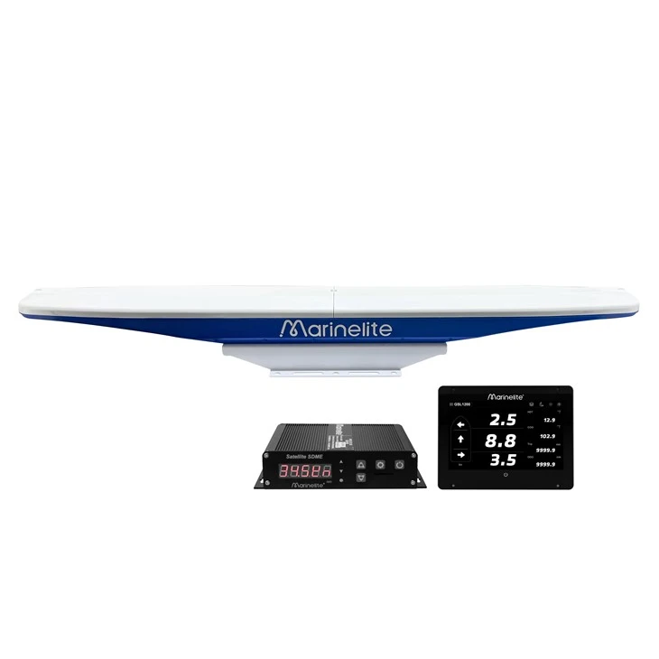
nThis product is a navigation instrument to measure the ship’s speed and accumulated voyage. It provides precise position information and speed and direction information for ship owners, and realises the display and warning of ship’s movement status information.
n
n
n
nAs a professional Speed and Distance Measuring Equipment (SDME) compliant with international standards like IEC 61023, the Marine Satellite Speed Log SDME is engineered to resolve the most frustrating navigation challenges faced by mariners, skippers, and vessel operators every day. Unlike traditional electromagnetic or Doppler speed logs that struggle with fouling, shallow water inaccuracies, or complex maintenance, this satellite-based system leverages GNSS technology to deliver reliable, high-precision speed and distance data-eliminating the guesswork that puts voyages at risk and cuts into operational efficiency. It directly addresses the core issues mariners face: inconsistent speed readings in rough seas, inaccurate data during low-speed berthing, signal interruptions in coastal or congested waters, and the hassle of frequent maintenance. Whether you’re navigating a large commercial vessel needing precise speed data for SOLAS compliance, a coastal fishing boat tracking fuel efficiency, or a cargo ship requiring accurate distance logs for voyage planning, this device adapts to your needs. It provides real-time longitudinal and transverse speed (even at the bow and stern), integrates seamlessly with ECDIS, radar, and AIS systems, and operates without mechanical parts-meaning less downtime and no repeated maintenance costs.
n
nBenefits:
nFirstly, they are accurate and reliable, providing real-time data on a vessel’s speed and distance travelled. This can be crucial in a range of situations, such as when navigating through busy shipping lanes or during bad weather. It can also help shipping companies to optimize their routes and reduce fuel consumption, as well as providing vital information for reporting and compliance purposes.
nIn addition, satellite speed logs are easy to install and maintain, and can be integrated with other onboard systems. This means that vessel operators can access a range of data and information in one place, simplifying navigation and monitoring processes.
n
n
n
nProduct Features:
n
n
n
n
n
n
n
n
n
nTechnical parameters:
n
n1. General
n
| 1.1 Measurement range | |
| Speed | -99.9 to +99.9 kn |
| Trip distance | 0.0 to 9999.9 nm |
| Heading | 0.0 To 359.9° |
| Accuracy | |
| Speed | 2.0% or 0.2 kn whichever is the greater |
| Heading | GSL1200: 0.2°RMS |
| Roll/Pitch | 0.3°RMS |
| Following-up | 90°/s |
| Settling time | 120s approx. |
| Power supply | 11~36V |
| Receiving frequency | GPS/GALILEO/BDS/GLONASS (optional) |
n
n
n
n2. Interface
n
| 2.1 Number of port | |
| IEC61162(NMEA0183) | IEC61162-2: 2 port, IEC61162-1: 2 port |
| LOG PPS | 2 port |
| 2.2 Data port | |
| VBW, VHW, VLW HDT, ZDA,RMC, ROT, GBS*, GGA*, GLL*, GNS*, GRS*, GSA*, GST,* GSV*, HDG*, THS*,VTG* | |
| 2.3 Output proprietary sentence | SHR* |
n
nNote: output the sentence with * requires contact your dealer.
n
n
n
n3.Environmental conditions
n
| 3.1 Ambient temperature | |
| Antenna unit | -25 ℃ to 70 ℃ |
| Junction box | -15 ℃ to +55 ℃ |
| 3.2 Relative humidity | 95% or less at +40 ℃ |
| 3.3 IP protection | |
| Antenna unit | IP56(Exposed) |
| Junction box | IP20(Protected) |
| 3.4 Vibration | IEC 60945 Ed.4 |
n
n
n
nApplication Guide
n
nGetting Started: Initial Setup
nBefore launching your voyage, spend 15 minutes setting up the Marine Satellite Speed Log SDME to ensure optimal performance. Start by mounting the satellite antenna in a location with a clear view of the sky (avoiding masts, cranes, or other obstructions) and secure it with the included bracket. Connect the antenna to the junction box using the 20-meter cable, then plug the junction box into the vessel’s 12/24V power supply. Optional a 7-inch display unit, and connect the 7-inch display unit to the junction box.Turn on the device and follow these steps: 1) Choose your preferred units (knots for speed, nautical miles for distance). 2) Enable multi-constellation mode to ensure reliable satellite reception. 3) Adjust the speed filter to medium (2-3 seconds) to balance accuracy and stability. 4) Calibrate the display brightness for your bridge conditions (use the dimmable backlight for low-light or bright sunlight). Finally, run a self-test to confirm the device is transmitting data correctly-this takes 1-2 minutes and ensures compliance with maritime standards.
n
nUsing the Device During Voyages
n
n- Integrate with navigation systems: Ensure the device is transmitting data to your ECDIS, radar, and AIS-this enhances collision avoidance and route optimization. Check the data transmission status regularly (via the menu) to confirm all systems are receiving accurate speed and distance data.
n- Track fuel efficiency: Use the distance and speed logs to calculate fuel consumption-correlating speed with engine output helps you identify the most fuel-efficient speed for your vessel, reducing operational costs.
n- Handle signal interruptions: If satellite signal is lost (indicated by a warning on the display), slow down slightly and move to an area with unobstructed sky. Enable multi-constellation mode to regain signal faster, and avoid relying solely on the device during signal gaps-use backup navigation tools if needed.
Not able to find the product you need in our catalogue?
Tell us what you need and we will search for you.